 eAtlas Data Catalogue
School of Business, James Cook University and The Cairns Institute
Type of resources
Topics
Keywords
Contact for the resource
Provided by
Representation types
status
-
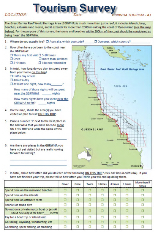
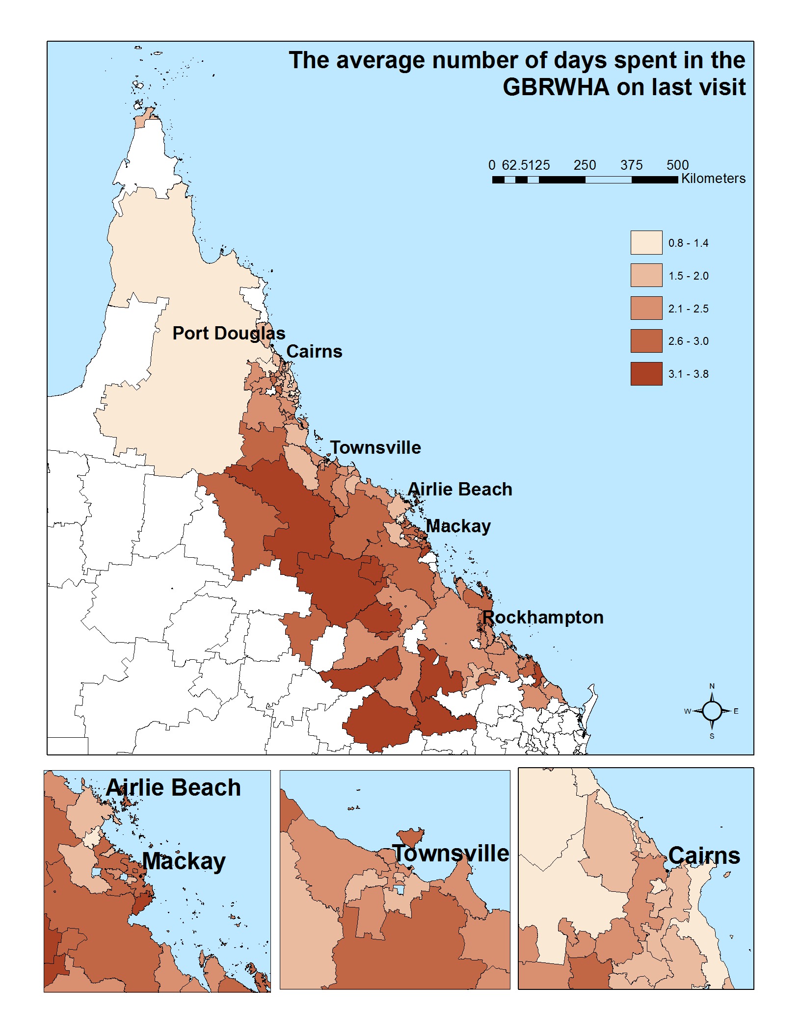
This dataset represents the aggregate of face to face surveys of 2743 visitors to the Great Barrier Reef World Heritage Area (GBRWHA) conducted in quarterly periods from June 2012 to June 2013. This survey was to explore how tourists feel towards and perceive Great Barrier Reef World Heritage Area, as well as their willingness to pay to protect the reef and their satisfaction with current and future developments in and around the GBRWHA. Due to privacy constrains this dataset does not correspond to the raw survey results, but instead is an aggregate of views of tourists from different origins. The format of the data is an Excel spreadsheet. The core segments of the tourist questionnaire included questions about: * The socio-demographic background of respondents PLUS background about travel party and origin * How often visitors had been to the GBRWHA in the past and what they did (or planned to do) while on this particular trip * Questions about the importance of various ‘goods and services’ to their overall decision to come to the region (in contrast to the resident survey which asked about importance to overall quality of life). * Their satisfaction with the trip overall (in contrast to the resident survey which asked about satisfaction with life overall) * The way in which their decision to come to the region would have been affected by changes in various environmental and market factors (in contrast to the resident survey which asked about the way these things would affect overall quality of life). * Expenditure while in the area * Willingness to pay for improvements in various environmental attributes This tourist survey was developed in combination with a matching resident questionnaire. Data was collected from visitors to the GBRWHA region in 59 location along the coast from airports, ferry/boat operators, caravan-park owners and beach / lagoon areas in Cairns, Port Douglas, Townsville, Bowen, Airlie Beach, Rockhampton and Yeppoon. Enumerators collected data using a questionnaire specifically developed for the purpose of the project. Questionnaires were also available in Japanese and Chinese, with the presence of Japanese and Chinese speaking enumerators. Data collection occurred in 4 time periods over the June 2012 to June 2013 year, to account for seasonality of the tourist visitations. In addition to this data was collected from a stratified random selection of tourism operators between Cooktown and Gladstone. From an initial list of 673 tourism operators they were divided into the accomodation sector, tour operators and tourism 'attractions'. In total 36 operators agreed to participate and resulted in 203 completed surveys. In line with the national Ethical Conduct in Human Research guidelines and JCU Ethics Committee Approval for this research, raw data collected from individuals cannot be made publically available. Rather, data is collated into meaningful units and presented as such. This dataset is accompanied by the following factsheets in pdf format: 1. Activities and Preferences of Visitors to the Great Barrier Reef World Heritage Area 2. Activities and Preferences of Visitors to Townsville and Airlie Beach 3. Activities and Preferences of Visitors to Gladstone to Mackay region 4. Activities and Preferences of Visitors to Tropical NQ 5. Activities and Preferences of Chinese Visitors to Tropical NQ 6. Activities and Preferences of Japanese Visitors to Tropical NQ 7. Activities and Preferences of Queensland Visitors to Tropical NQ 8. Activities and Preferences of Domestic (non-QLD) Visitors to Tropical NQ. The data associated with this metadata record corresponds to an Excel data sheet containing the aggregate data used in the accompanying summary PDF fact sheets. Further details of the project, including data collection and analysis methods, can be found in: Stoeckl, N., Farr, M. and Sakata H. (2013) What do residents and tourists ‘value’ most in the GBRWHA? Project 10.2 interim report on residential and tourist data collection activities including descriptive data summaries. Report to the National Environmental research program. Reef and Rainforest Research Centre Limited, Cairn (pp112) Available online from: http://www.nerptropical.edu.au/research
-
This data set in excel sheet format presents results of the mail survey of 1565 residents of the GBRWHA. The dataset is accompanied by a set of 58 maps that illustrate key findings. Project 10.2 explored how visitors and residents feel towards and perceive Great Barrier Reef World Heritage Area, as well as their willingness to pay to protect the reef and their satisfaction with current and future developments in and around the GBRWHA. Data were collected from the residents of the GBRWHA using a mail-out survey to a geographically stratified random sample of resident households in postcodes that lay partially or entirely within the study area. The pilot stage included 230 randomly selected households (2 from each of the postcodes identified), while the main mailing included about 40 households in each postcode. Following the Dilman (2007) methodology, we sent a reminder letter with replacement questionnaire to those who had not responded four weeks later, with a third reminder after that. We estimate that just under 4,000 questionnaires reached their intended recipients, and we received 902 completed questionnaires. We were cognizant that some demographic groups are more likely to respond to mail-out surveys than others in these regions (e.g. young males, Indigenous people). Therefore we conducted supplementary face-to-face data-collection using the same questionnaire, across various public locations such as ferry terminals, airports and beaches. These extra activities generated an additional 663 responses, bringing the total number of completed resident questionnaires to 1565. Data Format: Excel data sheet with each row representing a postcode within the Great Barrier Reef Catchment Area and each column providing summary information about one variable (e.g. % or respondents who have never been to the GBRWHA). The GIS maps represent the data visually (one variable per map, showing responses for each postcode). The original raw data cannot be published for privacy reasons. Data available here is a public form of the data, aggregated by postcode. Further details of the project, including data collection and analysis methods, can be found in: Stoeckl, N., Farr, M. and Sakata H. (2013) What do residents and tourists ‘value’ most in the GBRWHA? Project 10.2 interim report on residential and tourist data collection activities including descriptive data summaries. Report to the National Environmental research program. Reef and Rainforest Research Centre Limited, Cairn (pp112)